Showing posts with label A Guide for Mountaineering in Java. Show all posts

Friday, August 21, 2009

IJEN CRATER (2,300 m)

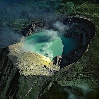
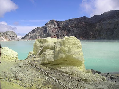
Ijen craterIjen Crater is an active one which is combination of Mt. Raung and Mt. Ijen. There are two main routes leading to the crater. The first route is from Banyuwangi to the south-west through Jambu village. By mini bus from Banyuwangi, we go to Licin village and by another mini bus go to Jambu village, as the last village.

From the Jambu village, we start trekking by passing Coffee and Clove Plantation along the way to a splendid tropical forest. This way is used daily by the workers to carry sulfur stores from Ijen Crater, so the path is quite wide and good. In the middle of the journey, we will find cold water from a small river. It will take 4 hours before getting at a prairie. There are three locked huts and some water from rain. We need another 1 and half hours to reach to the crater. On the way, there is a small office managing sulfur mining, in which we can buy drinks or cigarettes.
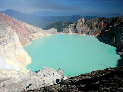
ijen crater
The second route is from Bondowoso to southeast passing Wonosari and Ijen Kaldera which is he biggest kaldera in Indonesia. From Bondowoso, just straight to Wonosari – Sukosari and continued to Sempol. Sempol is the nearest village to Ijen Crater and there is no inn there.
ijen crater
We will takes 5 hours passing beautiful savanna, to reach the three locked huts above from Sempol. We can rent a car from Wonosari or Sempol to go to Pal Tuding to minimize time is minibus rarely passes there. It will spend another 2 hours, trekking from Pal Tuding to the tree locked huts.

Ijen Crater forms a lake with boiling light green color water whose sides strongly blows sulfuric gas. Ijen Crater is one of the most fascinating panoramas in Java Island.
NEXT ->>...

Monday, January 12, 2009

Mt. CIREMAI (3,078 m)

Mt. CIREMAIMt. Ciremai has its own characteristic compared with other mountains in Java Island. This mountain is far away from the other mountains and situated close to the Java Sea.

To reach the mountain, we may travel by bus from Cirebon going to Kuningan and get off at Cilimus. From Cilimus we can travel by motor cycle or mini bus to Linggarjati.

To climb the mountain, we should obtain a letter of permission from Kuningan’s Forest Authority (PERHUTANI) and formerly from the police station of Kuningan. After receiving the letter, the village headman of Linggarjati will give us the permission by return to go on further.

We may stay overnight in Linggarjati Hotel. Walking 700 m westwards to Gedung Naskah from the Hotel, we will reach Linggarjati village hall where we will find many guides who will lead us to the mountain.

If we walk from this place towards the mountain, we will come across a pine woods and find a place called Cibunar, where the path is bifurcation. In this place we can put up a tent, and obtain water. We should turn left, where the path will lead us to the Mt. Ciremai. Afterward, we will come across to tropical forest, in the middle of which we can find a place called Linggak, a plain with many big stones. In Linggak we may take a rest and put up a tent to stay overnight.


It takes about 5 hours to reach Linggak from Linggarjati and other 2 or 3 hours to reach the peak (crater rim), through grassy hill. Climbing down about 1 or 2 hours right side from the peak, we will find a small sulfur crater. Walking around the crater rim leisurely for about two and half hours, we can enjoy the panoramic view of Majalengka, Bandung, Java Sea and other places. It takes about3 or 4 hours to return to Linggarjati.

Usually the foreign tourists prefer to climb the mountain peak in the early morning about 5:00 or 6:00 a.m. and return to i next day about 2:00 or 3:00 a.m. Domestic tourist prefer to go about 8:00 or 10:00 p.m. and return 2:00 or 3:00 p.m. next day. Frequently, many visitor come around on holidays, Saturdays and Sundays.
NEXT ->>...

Mt. PANGRANGO (3.019 mdpl) and Mt. GEDE (2.958 mdpl)

Mt. PANGRANGO and Mt. GEDE. Situated West Java, we can see the peaks of Mount. Pangrango and Mount. Gede from Cibodas. Mt. Pangrango is of steep triangular shape whereas Mt. Gede is of domed shape.

The most common routes leading to these mountains is the route from Cibodas. From Bogor or Cianjur, we can travel by bus going towards Cipanas and get off at the entrance of Cibodas, approximately 2 km away from the west of Cipanas. From that bus stop we can go on towards the gates of Cibodas ‘Botanical Garden’ by mini bus. We can obtain a permission of climbing from ‘Wisma Cinta Alam’ (the local authority office), which is on the right side of the gate. Guides are also available here.
Mt. Pangrango and Mt. Gede are part from the National Park, where we can enjoy beauty of nature. We can obtain Guide map of the National Park from "Wisma Cinta Alam". To enter the park, we have to walk through the Botanical Garden gate and come to the Guard House where we have to register our identity for personal security. If we wish, we can put up a tent.

Pangrango

Behind the guard house is the way to climb the mountains. On the way up, we come across a beautiful tropical forest. Walking about 4 hours, we will reach ‘PONDOK KANDANG BADAK’ hut. On the way we will find two or three huts, spring and hot spring. In this place, we may enjoy taking a dip in that hot spring. We can stay overnight in Pondok Kandang Badak where cold water is also available.

It is bifurcated path uphill from Pondok Kandang Badak, the right one going towards MT. Pangrango and the left one going towards Mt. Gede. To reach the peak of Mt. pangrango, we have to climb for about 2 hours walking through natural forest at 1.000 m high. The peak of Mt Pangrango is located in a thick and moldy forest, from where no view is visible. Climbing down the peak westward, we will find the field of Javanese ‘Edelweis’ flower, called as ‘Lembah Sura Kencana’. In the south of the field there is a hut where we can take a rest.


Climbing another 1 hour, we will reach the peak of MT. Gede. From the peak, we can enjoy a broad view of a scenic panorama and an exotic scene of the big wall Kaldera. Mt. Gede has three living craters. Climbing about 1 hour, we can reach the highest peak of Mt. Gede, where we can enjoy the panoramic view towards Jakarta, Cianjur, Sukabumi and other places. From the other side of the peak we can climb down to the north to reach Cipanas or to the south to reach Sukabumi. It takes about 3 hours to reach any of these places.
NEXT ->>...

MT. RAUNG (3,332 MDPL)

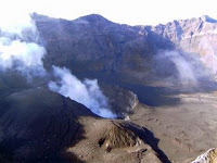
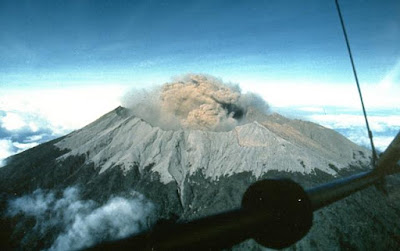
MT. RAUNGMT. RAUNG. Mt. Raung is a unique and big mountain in Java Island. Its uniqueness is found in its Kaldera whose depth is 500 m, which regularly blows smokes and fire. There is Kaldera in the peak, which is surrounded by many small peaks which give us enchanting scenery.

The easiest way to reach Mt. Raung is from Bondowoso. From Bondowoso we can take a mini bus to Sumber Wringin through Sukasari village. Start the trekking from Sumber Wringin through pine forest and Coffee Plantation to “Pondok Motor” (Climber Post) in which we can meet the key keeper named Mr. Serani. We can take a rest there to prepare our self for nine hours climbing to the peak of Mt. Raung.

MT.RAUNG
Climbing to the peak, we will pass through coffee plantation, pine and casuarina trees, before reaching the camping ground. For about 1 hour we have to go on a sedge and then another 1 hour on a sandy and stony path to the peak of Mt. Raung. It will take 7 hours to return to Sumber Wringin village.

Mt. Raung is 3,332 m high above sea level where strong wind often blows. There is another higher peak, but there is still no way to reach it, as it is a dense forest.

MT. RAUNGCaldera of Mount. Raung


As there is no water on the way to Mt. Raung, we’d better have sufficient water prepared from Sumber Wringin or Sumber Lekan. There is no special permission required to climb Mt. Raung, we just need to inform the village officer in Sumber Wringin.
NEXT ->>...