Showing posts with label Trekking. Show all posts

Saturday, May 9, 2009

Taking Mountain Climbing Rescue Course

Taking Mountain Climbing Rescue Course. The following are some of the rescue mountain climbing courses offered by some of the premier emergency and rescue response institutions. They have also taught all and every manner of emergency outdoor response.

Rescue rock essentials
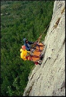
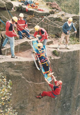
Mountain Climbing Rescue CourseThis is a rescue type course that offers an intro to rescuing the self through a series of rope systems especially for mountain climbing. Also offered is a three day course version. The focus of the rescue rock essentials is safety, lowering, raising as well as self rescue. Included in the course are safety rappelling, improvised stretchers as well as carries. Believe it or not, this course also comes with first aid info, it is a necessity that all mountain climbers have such basic first aid training.

Rescue high angle dynamics

This is a course that runs from 5 to 7 days and is specifically designed for the participants to be introduced to a wide range of basic skills rescue as well as transport for those injured in a difficult terrain or in high angled positions.

Much of the course involve procedures of extrication as well as rescue on vertical and steep rocks. Participants of this course are also introduced to rappelling, belaying, equipment and knots, carries, anchors, system raising, use of litter, system lowering as well as a wide range of technical subjects.

The fact of the matter is that there are two rescue stream courses offered, one is for leaders of wilderness as well as for professionals. Wild and hard rescue

This rescue is taken best by those cavers, climbers, river travelers whose role in a group is that of a leader. Any and all participants of this course need to have knowledge of basic knots and ropework.

The first level involve rescuing self as well as skills in handling a rope. Included in the course is rescue rappelling and a system of counterbalance. Ascenders and prusiks as well as their proper use is also included.
Mountain Climbing Rescue Course
Rescue high angle professional dynamics

This is a course that stretches to five days and is designed to help participants have a wide range of basic rescue transport and skills for those injured in a high angle or difficult situation.

Participants who have taken part in such courses have advised that their confidence and courage in being able to deal with challenging mountain climbing situations have increased. All in all, learning mountain climbing rescue courses is essential for those who do mountain climbing regularly. Cliché as it may sound, the life you save could just as well be yours.
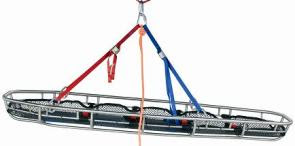
Mountain Climbing Rescue CourseDesigned for high angle

Source : www.goarticles.com
NEXT ->>...

Friday, May 8, 2009

The Different Conditions Of Mountain Climbing

Mountain climbing is ascending elevated points of mountains or peaks. This is a challenge to those who dare themselves to heights. It is often done in groups because it not only requires individual skill but teamwork as a whole.

Mountain climbing is divided into three categories. The first one is hiking or trail climbing. This is the least difficult. Participants hike up trails to reach the top of a mountain. Trails are usually not that steep and the mountains are smaller compared to the rest.

The second category is rock climbing. Here, participants climb up larger mountains, therefore the slopes are steeper. They have to go up using their hands and their feet plus a special equipment including rubber boots with thick soles. They have to bring with them steel pikes called pitons and rope to assist them.

Ice climbing is the most difficult among the three. Here, participants climb extremely high mountains with peaks above the timber line. The equipment usually used in ice climbing are ice axes and boot spikes that are attachable (crampons).

Famous climbs over the years are those of ice and rock climbing. However, the first significant mountain climbing turning points were those at Mont Blanc. One was by Michel G. Paccard and Jacques Balmat in 1786 and Horace B. de Saussure in 1787.

Then there is the climb of the Ortles in 1804, Jungfrau in 1811, Finsteraarhorn in 1812 and Mont Pelvou in 1848.

Mountain climbing enthusiasts are all required to be aware of the various trail conditions that could take place on the day of their climb. Hikers must know that the weather is unpredictable and whatever changes might occur, this can affect their expedition.

Here are a couple of trail conditions and what a mountain climber must do once he encounters them:

  1. Open There are no restrictions. Any mountain climber can hike through the trail.
  2. Partial Some of the roads leading to a couple of paths are off limits for mountain climbers. Only a portion of the trail is accessible. This could be due to the snow, wildlife closure and trail damage right ahead.
  3. Closed Mountain climbers can no longer hike when this sign is up. A closed trail can be due to forest closure, road damage and wildlife closure.
  4. Snow The trail is still open but this sign warns the mountain climbers that there is snow in the area.
  5. Inaccessible The trail can't be accessed because of closure and road damage on the trails and the roads that are leading to it.
NEXT ->>...

Monday, May 4, 2009

Techniques Of Mountain Climbing

Techniques Of Mountain ClimbingTechniques Of Mountain Climbing. If you're looking for a fun, enjoyable and exciting way to use up your free time, you can try mountain climbing. Studies show though that avid mountaineers are those who have no family, friends or loved ones. Why? Because this is a risky sport to engage in.

If you've fully decided to try mountain climbing, here are some tips that can help you reach the peak.

  1. Choose which mountain to climb. Decide on your route. Get the best one that is most suitable for you and your group. Remember to choose a mountain that is appropriate for the technique you will apply. For example, if you are using rock climbing techniques then choose a mountain that has a low-rising footpath. In that way, you won't be scraping your knees along the edges as much. If you also choose to hike through the summit but one that has overhanging ice, you won't be able to reach the top.
  2. You have to be aware that with each step you take, the terrain gets steeper. Therefore, there is less oxygen and the climate gets harsher. Each step you take is more difficult.
  3. Equip yourself with the proper gear. You can get these at any outdoor sports store. There are also some in junkyards or yard sales. But if you are investing in this activity, then you might as well get first-hand gear, right?

Your gear should include the following: - backpack - pair of boots - coat - canteen to be filled with water - food that would last you during your entire excavation - first aid kit - flashlight - sunscreen - sunglasses - map - friend or companion. Never climb alone.
You can also bring a rifle (to protect yourself from wild beasts out there) and enough ammunition. If you're ice climbing, bring an ice axe and warm clothing. Don't forget the rope because this will be very useful.

When you're actually climbing the mountain, you have to get to it first. Upon arriving at the base of the mountain, you have to know what you're doing before you start out. Always be safe with each step you take. Keep your ice axe within reach just in case the situation calls for it. Don't get hypothermia. Don't get lost. Don't panic. These are a couple of key rules. Most importantly, have fun.

Website : www.goarticles.com
NEXT ->>...

Monday, January 12, 2009

Mt. CIREMAI (3,078 m)

Mt. CIREMAIMt. Ciremai has its own characteristic compared with other mountains in Java Island. This mountain is far away from the other mountains and situated close to the Java Sea.

To reach the mountain, we may travel by bus from Cirebon going to Kuningan and get off at Cilimus. From Cilimus we can travel by motor cycle or mini bus to Linggarjati.

To climb the mountain, we should obtain a letter of permission from Kuningan’s Forest Authority (PERHUTANI) and formerly from the police station of Kuningan. After receiving the letter, the village headman of Linggarjati will give us the permission by return to go on further.

We may stay overnight in Linggarjati Hotel. Walking 700 m westwards to Gedung Naskah from the Hotel, we will reach Linggarjati village hall where we will find many guides who will lead us to the mountain.

If we walk from this place towards the mountain, we will come across a pine woods and find a place called Cibunar, where the path is bifurcation. In this place we can put up a tent, and obtain water. We should turn left, where the path will lead us to the Mt. Ciremai. Afterward, we will come across to tropical forest, in the middle of which we can find a place called Linggak, a plain with many big stones. In Linggak we may take a rest and put up a tent to stay overnight.


It takes about 5 hours to reach Linggak from Linggarjati and other 2 or 3 hours to reach the peak (crater rim), through grassy hill. Climbing down about 1 or 2 hours right side from the peak, we will find a small sulfur crater. Walking around the crater rim leisurely for about two and half hours, we can enjoy the panoramic view of Majalengka, Bandung, Java Sea and other places. It takes about3 or 4 hours to return to Linggarjati.

Usually the foreign tourists prefer to climb the mountain peak in the early morning about 5:00 or 6:00 a.m. and return to i next day about 2:00 or 3:00 a.m. Domestic tourist prefer to go about 8:00 or 10:00 p.m. and return 2:00 or 3:00 p.m. next day. Frequently, many visitor come around on holidays, Saturdays and Sundays.
NEXT ->>...

Mt. PANGRANGO (3.019 mdpl) and Mt. GEDE (2.958 mdpl)

Mt. PANGRANGO and Mt. GEDE. Situated West Java, we can see the peaks of Mount. Pangrango and Mount. Gede from Cibodas. Mt. Pangrango is of steep triangular shape whereas Mt. Gede is of domed shape.

The most common routes leading to these mountains is the route from Cibodas. From Bogor or Cianjur, we can travel by bus going towards Cipanas and get off at the entrance of Cibodas, approximately 2 km away from the west of Cipanas. From that bus stop we can go on towards the gates of Cibodas ‘Botanical Garden’ by mini bus. We can obtain a permission of climbing from ‘Wisma Cinta Alam’ (the local authority office), which is on the right side of the gate. Guides are also available here.
Mt. Pangrango and Mt. Gede are part from the National Park, where we can enjoy beauty of nature. We can obtain Guide map of the National Park from "Wisma Cinta Alam". To enter the park, we have to walk through the Botanical Garden gate and come to the Guard House where we have to register our identity for personal security. If we wish, we can put up a tent.

Pangrango

Behind the guard house is the way to climb the mountains. On the way up, we come across a beautiful tropical forest. Walking about 4 hours, we will reach ‘PONDOK KANDANG BADAK’ hut. On the way we will find two or three huts, spring and hot spring. In this place, we may enjoy taking a dip in that hot spring. We can stay overnight in Pondok Kandang Badak where cold water is also available.

It is bifurcated path uphill from Pondok Kandang Badak, the right one going towards MT. Pangrango and the left one going towards Mt. Gede. To reach the peak of Mt. pangrango, we have to climb for about 2 hours walking through natural forest at 1.000 m high. The peak of Mt Pangrango is located in a thick and moldy forest, from where no view is visible. Climbing down the peak westward, we will find the field of Javanese ‘Edelweis’ flower, called as ‘Lembah Sura Kencana’. In the south of the field there is a hut where we can take a rest.


Climbing another 1 hour, we will reach the peak of MT. Gede. From the peak, we can enjoy a broad view of a scenic panorama and an exotic scene of the big wall Kaldera. Mt. Gede has three living craters. Climbing about 1 hour, we can reach the highest peak of Mt. Gede, where we can enjoy the panoramic view towards Jakarta, Cianjur, Sukabumi and other places. From the other side of the peak we can climb down to the north to reach Cipanas or to the south to reach Sukabumi. It takes about 3 hours to reach any of these places.
NEXT ->>...