Showing posts with label archipelago. Show all posts

Friday, August 21, 2009

IJEN CRATER (2,300 m)

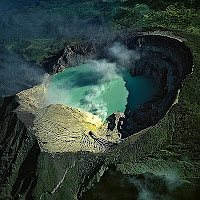
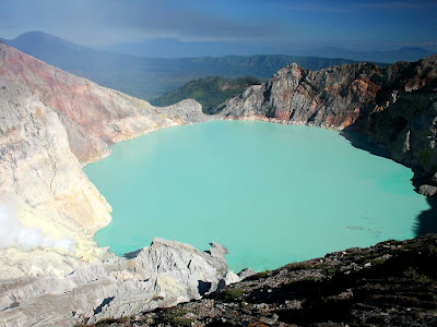
Ijen craterIjen Crater is an active one which is combination of Mt. Raung and Mt. Ijen. There are two main routes leading to the crater. The first route is from Banyuwangi to the south-west through Jambu village. By mini bus from Banyuwangi, we go to Licin village and by another mini bus go to Jambu village, as the last village.

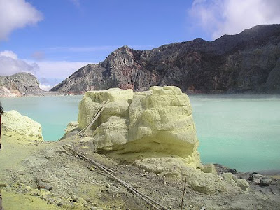
From the Jambu village, we start trekking by passing Coffee and Clove Plantation along the way to a splendid tropical forest. This way is used daily by the workers to carry sulfur stores from Ijen Crater, so the path is quite wide and good. In the middle of the journey, we will find cold water from a small river. It will take 4 hours before getting at a prairie. There are three locked huts and some water from rain. We need another 1 and half hours to reach to the crater. On the way, there is a small office managing sulfur mining, in which we can buy drinks or cigarettes.

ijen crater
The second route is from Bondowoso to southeast passing Wonosari and Ijen Kaldera which is he biggest kaldera in Indonesia. From Bondowoso, just straight to Wonosari – Sukosari and continued to Sempol. Sempol is the nearest village to Ijen Crater and there is no inn there.

ijen crater
We will takes 5 hours passing beautiful savanna, to reach the three locked huts above from Sempol. We can rent a car from Wonosari or Sempol to go to Pal Tuding to minimize time is minibus rarely passes there. It will spend another 2 hours, trekking from Pal Tuding to the tree locked huts.

Ijen Crater forms a lake with boiling light green color water whose sides strongly blows sulfuric gas. Ijen Crater is one of the most fascinating panoramas in Java Island.
NEXT ->>...

Monday, July 13, 2009

Beauty of the Beach "Tanjung Setia"

tanjung setiaBeauty of the Beach Tanjung Setia. Beach name "Tanjung Setia" Lampung in the west, is famous for the west. Besides the natural scenery, is also a challenging waves. Do not wonder if in the month of July to October plateau always surfing for foreign tourists, because waves reached seven meters.

Waves at the beach Tanjung Setia which dealt with the Indian Ocean, it's making for the special interest for tourists to surf. In addition to high and long waves, marine conditions are natural, and even the air is very mild and natural conditions of peace, far from noise.

Tanjung Setia
Beach that is located in a small bay, a location other than surfing for foreign tourists from Australia, the United States and other European countries, also known as a fishing trip where the rich tuna fish start to blue Marlin. Also, as a place to camp, let alone have a representative cottage even natural because the building integrates with nature.

Therefore, it is not over-the beach is "Pekon Bumi Agung", Biha District, about 22 km from the city Krui called hidden pearls. Because the waves with no less in the Bali and Nias. Also conditions the beach of fine sand, the pearl white trash and cleaning the beach is still awake.
NEXT ->>...

Thursday, May 14, 2009

Beautifulness of the Islands in Indonesia

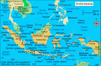
Beautifulness of the Islands in IndonesiaBeautifulness of the Islands in Indonesia. Indonesia is the largest archipelago in the world, consists of five major islands and about 30 smaller groups of islands, totaling about 17,508 islands and islets, of which around 6,000 are inhabited.

The name “Indonesia” came from two Greek words: “Indos” meaning India, and “Nesos” meaning islands. Indonesian archipelago forms a crossroad between two oceans, the Pacific and the Indian, and bridges two continents, Asia and Australia. This strategic position has always influenced the cultural, social, political and economic life of the country.

Indonesia consists of 33 provinces, which respectively divided into sub groups of regencies – cities, districts, and villages. The 33 provinces are: Bali, Banten, Bengkulu, DKI Jakarta (capital), DI Yogyakarta, Gorontalo, Irian Jaya Barat, Jambi, Jawa Tengah, Jawa Barat, Jawa Timur, Kalimantan Barat, Kalimantan Selatan, Kalimantan Tengah, Kalimantan Timur, Kepulauan Bangka Belitung, Kepulauan Riau, Lampung, Maluku, Maluku Utara, Nangroe Aceh Darussalam, Nusa Tenggara Barat, Nusa Tenggara Timur, Papua, Riau, Sulawesi Utara, Sulawesi Tengah, Sulawesi Barat, Sulawesi Selatan, Sulawesi Tenggara, Sumatera Barat, Sumatera Selatan, and Sumatera Utara.

Beautifulness of the Islands in Indonesia

The territory of the Republic of Indonesia stretches from 6 08' north latitude to 110 15' south latitude, and from 940 45' to 1410 65' east longitude. Its estimated total area is 9.8 million sq km, consists of a land territory of 1.9 million sq km and sea territory of 7.9 million sq km, which constitutes about 81% of the total area of the country.

Five main islands in Indonesia are: Kalimantan or two-thirds of Borneo (539,460 sq km), Sumatra (473,606 sq km), Papua (421,981 sq km), Sulawesi (189,216 sq km), and Java (132,187 sq km), the most fertile and densely populated island. The other islands are smaller in size.

The Indonesian archipelago is divided into three major divisions. The islands of Java, Sumatra and Kalimantan, together with the small islands in between, stand on the Sunda Shelf which extends from the coast of Indonesia’s land area is generally covered by thick tropical rain forests where fertile soils are continuously replenished by volcanic eruptions like that on the island of Java. The island of Java has 112 volcanic centers of which are active. The lava ejected has a high degree of fertility.

An additional advantage of the island of Java is that its coastal plains are not edged by wide swamps as in the case of Sumatra, Kalimantan and Papua, not bordered by coral reefs as in the case of the island of Sulawesi. On the island of Sumatra there is plenty of evidence of past volcanic activities, although the ejected material contained acid, which is of less fertility compared with Java.

Climate and Weather
Indonesia’s climate and weather is characterized by an equatorial double rainy season. Its tropical monsoon-type climate is characterized by slight changes of season and temperature, low winds, a high degree of humidity and periodical heavy rainfall.

Humidity and temperatures vary according to the season, but temperatures are affected additionally by time of day, height above sea level and proximity to the sea and exception. The dry season is from June to September, and the rainy season from December to March. The transitional period between these two seasons alternates between gorgeous sun-filled days and occasional thunderstorms.

Average temperatures are classified as follows: coastal plains: 28oC; inland and mountain areas: 26oC; higher mountain areas: 23oC, varying with the altitude. The humidity level is between 70 – 90 percent with a minimum of 73 percent and a maximum of 87 percent.

Areas
Indonesians usually refer to their homeland as Tanah Air Kita, which means "Our Land and Water." This world's largest archipelago extends some 2,000 kilometers from North to South and more than 5,000 kilometers from East to West. Nearly 60 percent of Indonesia's land is forest with a significant portion of mountains and volcanoes. Some mountains on Sumatra and Papua exceed 3,000 meters in height. Java alone has 112 volcanoes, some of which are active, including Krakatau, whose smoke in 1883 explosion was blown far away to Europe, in the Sunda Straits, Mount Merapi in Central Java, Mount Rinjani in Lombok island, and Mount Kelimutu in Flores, which hides lakes with three different colors (marine blue, aqua marine green and coca - cola brown red). Centuries of volcanic activity have led to high degree of soil fertility, which accounts in part for the high concentration of agriculture and people.

Although located in the tropics, the Jaya Wijaya peak in Papua (or "Irian") is an all-year-round snow-clad mountain, which attracts mostly Germany and French visitors. Another Mount Merapi in West Sumatra features a rivers-cut foothill that creates a beautiful picturesque Ngarai Sianok canyon on the edge of town of Bukittinggi.

Besides mountains and hills, there are many rivers and lakes scattered throughout the country that serve as substantial transportation or irrigation means. The longest river is the Kapuas in West Kalimantan, around 1,143 kilometers. A number of unique lakes are found in some areas, such as Lake Toba in North Sumatra (Samosir Island is located in central of lake), Lake Tempe, Lake Towuti, and Lake Tondano in Sulawesi, also Lake Paniai and Sentani in Papua.

Flora
Indonesia lies within the botanical region of Melanesia, which terrain is covered with luxuriant growth of the characteristics tropical rainforest vegetation. These characteristics differ Indonesian flora from neighboring continental Asia and Australia, as Indonesia represents approximately 40,000 species of plants, about 10 – 20 percent of the estimated number of plant species in the whole world, with many unique examples of tropical plant life and manifestations.

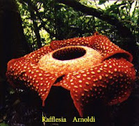
Rafflesia arnoldi, the largest flower in the world, is found only in certain parts of Sumatra. Another giant, Amorphoplalus titanium, the largest inflorescence of its kind, also comes from Sumatra. The myriad or orchids found in Indonesia are rich in species, varying in size, from the largest of all orchids, the tiger orchid Grammatophyllum speciosum, to the tiny and leafless species of Taeniophyllum.

Beautifulness of the Islands in Indonesia

The flora also abounds in timber species, such as the Dipterocarp family (meranti), the ramin (from species of Gonystylus), as well as resin and vegetable fat, tengkawang or illipe nuts. Indonesia is also well known for its teakwood, a product of man-made forest in Java.
Approximately 6,000 species of Indonesian plants are known to be used directly by the local people, especially for traditional herbal medicine, or “jamu”, and as indispensable part in ceremonies, customs and traditions.

Fauna
In the glacial period, Java, Sumatra and Kalimantan lay on the Sunda Shelf, and were joined to each other and to the mainland of Asia, but Papua and the Australian, at that time, lay on the Sahul shelf. This segregation explains why the typical oriental species in Java, Sumatra and Kalimantan are completely lacking in Papua, or species occur in Papua, such as marsupials, are not found in the oriental region.

Paleontological record reveals that the number of species known today is much smaller than in the past because of extinction of many species, due to normal ecological and evolutionary processes related to such factors as shifting sea levels, climatic changes and habitat alterations.

In order to safeguard and protect wildlife in Indonesia, the Directorate of Nature Conservation and Wildlife Management (or PPA) has adopted the modern natural conservation practice, for example, the establishment of “Orang Utan Rehabilitation” Projects in Sumatra and Kalimantan, in cooperation with World Wildlife Fund (WWF), for retraining illegally captured orangutans in the wilderness. In off the west coast of Flores, the Komodo dragon, world’s largest lizard, with a length of 2 – 3 has its home in the Komodo group of reserves.

Sulawesi has a unique fauna comprising many endemic species and many variations, such as babirusa (or pigdeer) and anoa (a forest-dwelling dwarf buffalo). Other endemic mammals of Sulawesi are the giant pam civet (the largest of all civets), tarsier, and several forms of Sulawesi macaque.

Papua and Maluku are rich in colorful birds, ranging from the great flightless cassowaries, brilliantly plumaged birds of paradise, to many numbers of parrot families.

Beautifulness of the Islands in Indonesia

Other members of oriental fauna are hornbills (family Bucerotidae), Sumatran and Kalimantan elephants, Sumatran and Java tigers, and one-horned rhinoceros in Ujung Kulon reserve (West Java). Thousands of species of birds, insects and aquatic animals are also available in Indonesia.

People
Due to Indonesia's emergence into an archipelago where its inhabitants, though of one similar ancestry, were separated by seas and therefore lost contacts, have caused the individual development of cultures, including their languages and their growing into diversification.
Nevertheless, the population of Indonesia has been reclassified, not so much on the basis of their racial origins, but more on the basis of their linguistics identities caused by mentioned diversification, into four ethnic groups: the Melanesians (the mixture between the Sub-Mongoloids with the Wajaks); the Proto-Austronesians (including the Wajaks), the Polynesians and the Micronesians. A pure classification according to their racial origins is difficult to realize due to their inter-marriages.

Members of the Melanesian race constitute by far the biggest majority of the population and include such major groups as the Minangkabau, the Bataks, the Malays and the peoples of Aceh, all on the island of Sumatra; the Sundanese and Javanese of Java; the Balinese; the Dayak people of Kalimantan, and the Minahasa, the Bugis and the Toraja of Sulawesi.
Representing the Polynesian and proto-Austronesian elements are the peoples of Maluku and Papua.

Population
Total population of Indonesia is estimated to be 220 million, with rate of growth 1.48 %, and placing it the world's fourth largest population after China, India and the United States of America.

The people are unevenly distributed throughout the archipelago. 60% are concentrated on three comparatively small islands: Java, Bali and Madura, which represent only 7% of the total land area. Jakarta, the capital city, which accounts for only 0.4 percent of country's total area, is the home to about 4.01 percent of country's total population, making its population density stood at 12,985 heads per sq km.

Languages and Dialects
An estimation of 150 to 250 languages and dialects are spoken and written in Indonesia, which usually classified according to the ethnic denominations, such as: Acehnese, Batak, Sundanese, Sasak, Timorese, Minahasa, Toraja, Buginese, Ambonese, several Irianese languages and other such languages. In between these languages exist many other different dialects.

However, the different groups are linked to unity by a common national language: the Indonesian Language or Bahasa Indonesia. Indonesia is proud of its great diversity of cultures and languages as symbolized in the state motto "Bhineka Tunggal Ika" which means Unity in Diversity. Bahasa Indonesia is the language of instruction and communications. It was proclaimed as the national language in 1928 in the early years of nationalist movements and originally the Malay language mainly spoken in the Riau islands, in eastern Sumatra. The language uses the Roman script and alphabet.

Although the Bahasa Indonesia has since been regarded as the Lingua franca yet local languages are equally valid and neither attempt, nor intention exists to abolish these local languages and dialects. Therefore the greater parts of Indonesian nationals remain bilingual.
NEXT ->>...

Wednesday, December 17, 2008

"PANCURAN PITU" BATURADEN

Pancuran Pitu Batu Raden. Baturaden is a natural attraction at Banyumas, Central Java on the north of Purwokerto. It is about 20 km from Purwokerto that may take 15 minutes. 2 kilometers from Baturaden there is a hot spring waterfall called Pancuran Pitu. Pancuran means or small waterfall, while pitu means seven.


This tourism destination is on the slope of Mount Slamet. For people from the tropical country, its temperature is cold enough, about 18° Celsius - 25° Celsius. Going there on the rainy season is a bad decision, the best is on the dry season so that we can explore the jungle or climb Mount Slamet.

Baturaden

The entry ticket is IDR7,500 for domestic visitor and IDR15,000 for the foreign visitors. Here, tourist may enjoy the hot spring water, Sarabadak Cave, Mountain View and enjoy the fresh air.

Baturaden

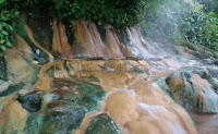
Since the water is sulphuric, many people use it to cure skin problems. The people usually take a bath at the waterfall or just immersing their feet in the pool. The yellow color is caused by the sulfur that remains on the stone. The water’s temperature is about 60° Celcius, hot but its really fun to immerse our feet. It seems that the water relax the nerves. When we are tired, we can pay a massager to massage our body for about IDR15,000.

Accommodation
There are many hotels at Baturaden from the lowest price to the higher. When I was there, I booked Madurodam Hotel. The price is starting from IDR150.000 per night, it vary depends on the room. Small but clean, good food and I can sleep well.

Baturaden

To get there
It is very easy to get to Pancuran Pitu. A tourist can take a bus or a train to Purwokerto. From Purwokerto find bus to Baturaden for about IDR10,000.
NEXT ->>...

Sunday, December 14, 2008

Govt Proposes Mount Rinjani in Lombok as First Geopark

Mount RinjaniGovt Proposes Mount Rinjani in Lombok as First Geopark. The government has proposed to UNESCO that Mount Rinjani, Lombok Island, West Nusa Tenggara, be one of the world's geoparks under its auspices, subsequently becoming the first geological park in Indonesia."The proposal is being discussed at the Forestry Ministry and Culture and Tourism Ministry and will then be handed over to the UN Educational, Scientific and Cultural Organization (UNESCO)," Mount Rinjani National Park Center head Arief Toengkagie told The Jakarta Post recently. There are 53 geoparks around the world located in 17 countries. One of them is in Southeast Asia - Langkawi Island in Malaysia. Rinjani would become the first designated geopark in Indonesia. Arief said Mount Rinjani, at 3,726 meters above sea level, should become a geopark given its natural beauty and unique geology -- such as the Segara Anak Lake, situated 2,000 meters above sea level and its crater, hot springs, waterfall and the formation of a new mount within a caldera named "Baru Jadi".

Mount Rinjani

"Domestic and foreign visitors have so far shown a keen interest in visiting the area, especially for mountain climbing. The status as a geopark will be very beneficial in enhancing its overseas promotion campaigns," he said.Besides its potential as a geopark, the flora, fauna and local culture of communities living around the area also adds to its allure. For example, the culture of the traditional village of Senaru, located at one of the trail entrances on Mount Rinjani, has been preserved for centuries. Tourists can also visit the Wetu Telu Muslim community complex and the Hindu Ngulam Pakelem ritual at Segara Anak Lake, held every six months. Mountain climbing supervision is uniquely managed by the local community, called the Rinjani Trek Management Board (RTMB). It is made up of members from the local administration, tour operators and the local community. RTMB previously won the 2004 World Legacy Award, organized by Conservation International and National Geographic Traveler Magazine. Rinjani was also a finalist for the Tourism for Tomorrow Award in 2005 and 2008. "The awards have been presented for our ability to conserve nature and to improve the local people's welfare," Arief said. The national park comprises around 40,330 hectares and administratively encompasses West Lombok, Central Lombok and East Lombok regencies. As an entity, Mount Rinjani is one of the province's prime tourist destinations. It is the second tallest active volcano in Indonesia after Sumatra's Mount Kerinci (3,800 meters). It last erupted in 2004. Based on studies, Mount Rinjani has erupted several times on a large scale. The series of eruptions eventually formed the Mount Rinjani National Park, which has a morphology rich in rock formations and naturally forms an impressive landscape, besides functioning as a catchment area. So far this year the park center has recorded 2,800 foreign and 3,100 domestic visitors who scaled the mountain between March and August and registered at three official routes -- Senaru and Tembilo in West Lombok and Sembalu in East Lombok."Our target is 5,000 foreign climbers before the end of September provided the weather is favorable, an increase from last year's figure of 4,500," Arief said. Most of the foreign visitors come from various European and Asian countries as well as Australia. According to Arief, the proposal to designate Rinjani a geopark is a follow up to a 2007 proposal to UNESCO to turn it into a World Heritage Site."A World Heritage Site has several categories, one of them being the geopark. Becoming a world icon as a dedicated UNESCO geopark would help preserve Rinjani because everyone would be responsible and work together to conserve the area."


Mount Rinjani


NEXT ->>...