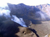
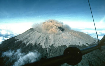
 MT. RAUNG. Mt. Raung is a unique and big mountain in Java Island. Its uniqueness is found in its Kaldera whose depth is 500 m, which regularly blows smokes and fire. There is Kaldera in the peak, which is surrounded by many small peaks which give us enchanting scenery.
The easiest way to reach Mt. Raung is from Bondowoso. From Bondowoso we can take a mini bus to Sumber Wringin through Sukasari village. Start the trekking from Sumber Wringin through pine forest and Coffee Plantation to “Pondok Motor” (Climber Post) in which we can meet the key keeper named Mr. Serani. We can take a rest there to prepare our self for nine hours climbing to the peak of Mt. Raung.

Climbing to the peak, we will pass through coffee plantation, pine and casuarina trees, before reaching the camping ground. For about 1 hour we have to go on a sedge and then another 1 hour on a sandy and stony path to the peak of Mt. Raung. It will take 7 hours to return to Sumber Wringin village.
Mt. Raung is 3,332 m high above sea level where strong wind often blows. There is another higher peak, but there is still no way to reach it, as it is a dense forest.
As there is no water on the way to Mt. Raung, we’d better have sufficient water prepared from Sumber Wringin or Sumber Lekan. There is no special permission required to climb Mt. Raung, we just need to inform the village officer in Sumber Wringin.
Related Post:
Mp3 Download


9 komentar:
Kok gak penah liat gunung ini ya..
padahal saya sering lewat Bondowoso..
hihi jd pengen deh kapan2....
:)
keren.,...
wah,,, keren euy... padahal aku juga orang jatim... kok gak tau ya???? dongo aku....
bagus bgt..tp kok byk yg ga tau ya?? apa fotonya aja yg keren? hm...jadi pengen kesana
give u $mile
huff.. kpn ya bisa k situ.. pemandangannya pasti oke bgt.. ^o^
Upload lagi yg keren keren bro..
bagi para pendaki pasti tahu kalo gunung ini memang terletak di daerah jatim...
Post a Comment